The first full day in Iceland was planned to be spent exploring the Golden Circle—Gullfoss, Geysir, and Thingvellir. Those sites together are referred to as the “Golden Circle” because they all make up Iceland’s major tourist destinations.
Golden Circle is a popular tourist route that includes several notable natural attractions, such as the geysers at Geysir, the waterfall Gullfoss, and Thingvellir National Park, where the American and Eurasian tectonic plates meet. Additionally, the area is home to several historical sites, such as the ancient parliament site at Thingvellir, and the Skálholt church, which was once the seat of the bishopric of southern Iceland.
We woke up quite early in our hotel. After a decent breakfast, we hit the road. We slept in Thingvellir National Park, so our first stop was at the visitor center, about 25 kilometers from our hotel.
Thingvellir NP is Iceland’s most important historical site and place—where the Vikings established the world’s first democratic parliament, the Alþing, in 930 AD. There is not much that remains to be seen about that event. But the place is also essential as it contains a rift valley caused by the separating North American and Eurasian tectonic plates. Thingvellir National Park was established in 1930, and the rift valley was added to the UNESCO World Heritage List in 2004.
The rift valley was fascinating. We got from the visitors’ center the map of the suggested walk. From this viewpoint, there is an excellent view of the
Thingvallavatn (Thingvellir Lake) is Iceland’s largest natural lake. This 84 km2 lake was blue on that sunny day. The lake lies 100m above sea level, and its greatest depth is 114m. 90% of the water in Thingvellir Lake comes from springs and fissures beneath the lake’s surface or along its shore.
When we were enjoying the views, two tourist buses arrived, and we somehow realized that we would like to have more privacy than enjoy the walk in the rift valley. Therefore, we drove a couple of kilometers to another parking spot, peacefully enjoyed the views, and walked.
When driving towards Geysir, we made two stops—first in the coffee shop at the camping site and second at the K1 service station. We bought some salads at a K1 service station to have a picnic lunch.
The next stop was at the Geysir Center. The Geysir is the original blasting hot water spout, after which all other geysers worldwide are named. Since 1950, when Geysir did not gush water, tourists spoiled it by throwing rocks into the spring. But we saw Strokkur, the most reliable geyser, bursting upwards of some 20 meters of a plume. We saw it blow every 4 minutes. The view was impressive, even better from a distance on the hill. There are several colorful springs, bubbling milky pools, and steam vents around the field at the Geysir center. Enjoying the area is worth some time, but be careful; the water is boiling at 100°C.
What is Geysir?
Geysir, also known as The Great Geysir, is a geyser located in the Haukadalur valley along the Golden Circle route. It is one of the most famous geysers in the world and the first known geyser described in a printed source. The Geysir geothermal area also features several other hot springs and geysers, including the active geyser Strokkur, which erupts every 5-10 minutes. However, Geysir is mostly dormant, with eruptions occurring only occasionally.
The geyser was active for centuries, but its activity decreased significantly in the late 20th century. The geyser is now highly unpredictable and can go many years without an eruption. The name “Geysir” itself is derived from the Icelandic verb “geysa” which means “to gush,” and it is from this geyser that the English word “geyser” originates. The area around Geysir is also known for its beautiful landscapes and is a popular spot for hiking and sightseeing.

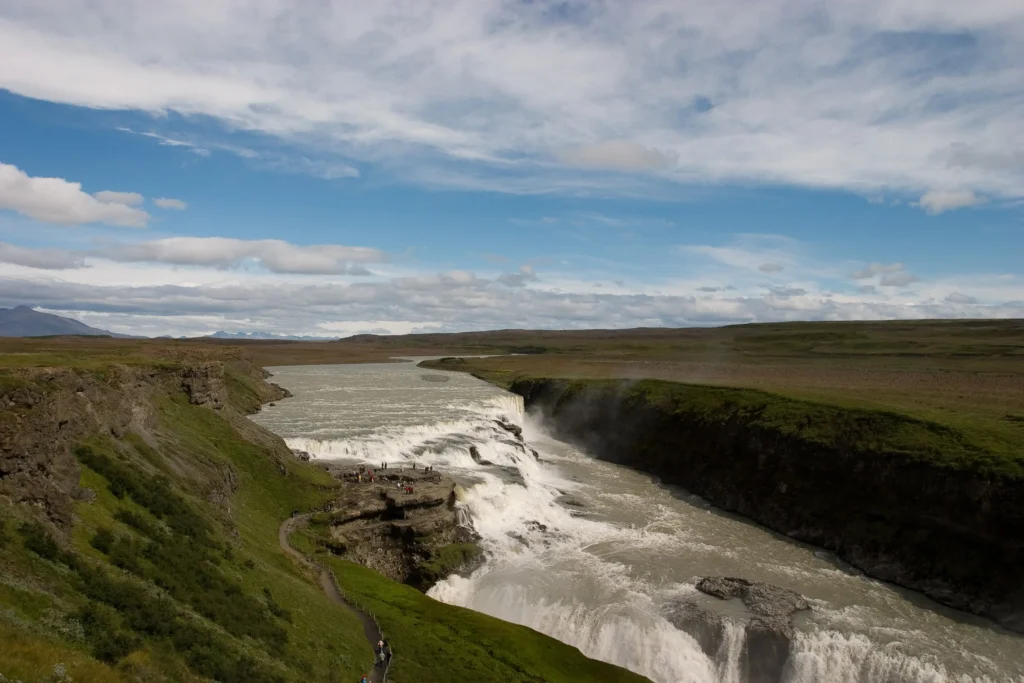
Gullfoss was about 10 km from Geysir field. Gullfoss is a spectacular double-cascading waterfall. As we had clear skies, the view was stunning. Due to the wind, photographing and videotaping were difficult. The number of visitors was also relatively high. We walked there, enjoying the views, and then had a picnic lunch on the hill’s south side: excellent views and good food—local salmon and salad.
After Gullfoss, we drove south to explore the Reykjanes peninsula. We made several stops. As suggested in LP, we stopped when the “Place of Interest” sign was present. We saw beautiful waterfalls, hot springs, volcano craters, and black beaches. The sand on the coast of the North Atlantic was black. Later, we even saw that children’s sandboxes were covered with black sand. This was odd.
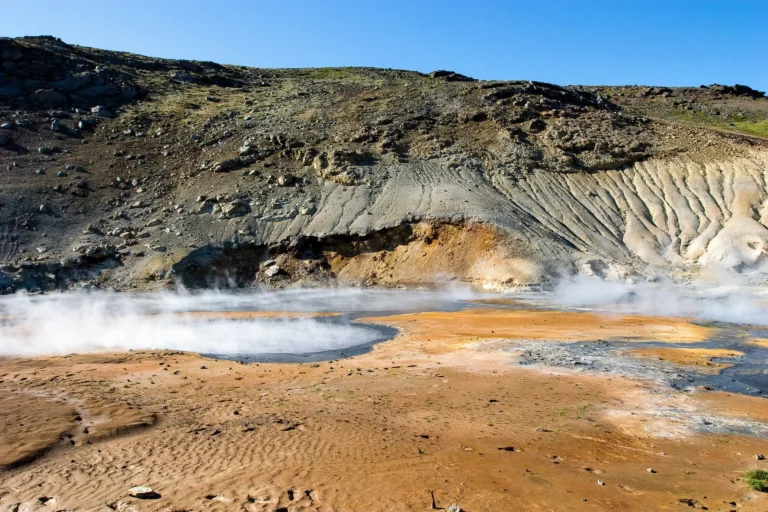
Another strange place was the Seltun geothermal zone. Here the mud was boiling and bubbling. A place worth visiting. Although the place was unplanned before the trip, it was something we expected to see in Iceland-a lot of hot springs. We also stopped at Kleifarvatn, a lake with unique color—it was bluer than any of the waters I have seen so far.
Driving on the Golden Route was easy—the roads are good, and traffic is rare. The traffic was even more occasional at the coast, although the roads were in bad condition. But driving on the Reykjanes peninsula lets us see many great views.
We ended our day at Fosshotel Nesbud in Nesjavellir. Again, we had a delicious dinner at Sagreifinn fish shop, and it was challenging to leave Reykjavik. Now we have obtained a better map for exploring around. After such a busy day, we took a rest in hot pots, and the sleep was good.
Related reading: